What Are Counties Anyway?
Counties are administrative divisions of a state. They are used to establish a local government and divide the state according to its needs.
In simple words, counties are subdivisions that make it easier and simpler to manage a State.

Every state in the U.S. has counties or county equivalents. They can be grouped in one or more judicial districts.
In some states, the county is the only legal division of the state; in others, it is part of one or more districts which may include cities and towns as well as unincorporated areas.
There are 3,243 counties in the United States, and most have their government and set of laws.
History of New York Counties
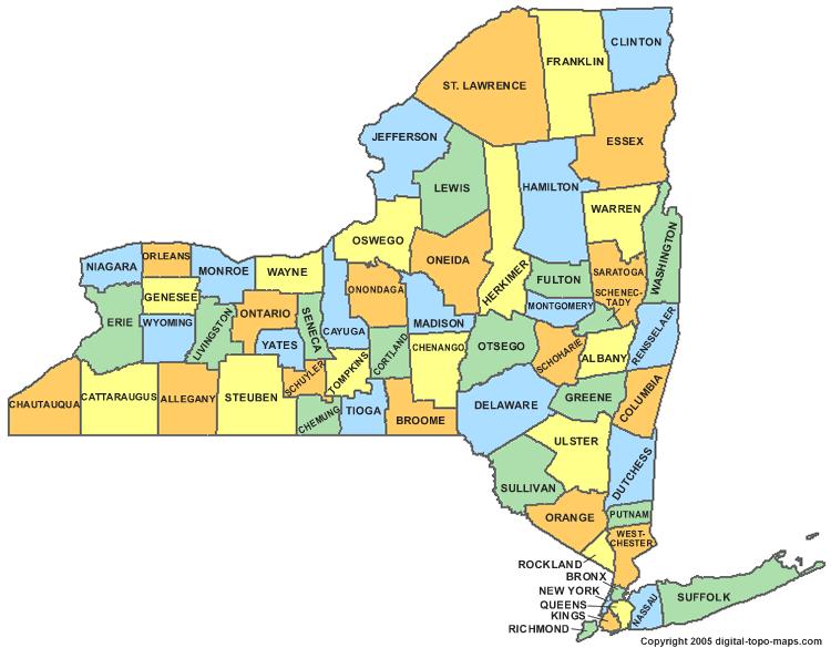
The state of New York is divided into 62 counties. The counties are the primary administrative divisions of New York State, with each county having its own elected government headed by a county executive and a county legislature.
The counties were established by the state legislature in 1683. They were used to divide up the land for settlement and taxation purposes.
Today they are still used for administrative purposes like assigning school districts, county seats, and voting districts.
There were 12 original counties created in 1683, which are:
Albany County, Cornwall County, Duchess County, Dukes County, Kings County, New York County, Orange County, Queens County, Richmond County, Suffolk County, Ulster County, and Westchester County.
However, Dukes County and Cornwell County have now been abolished.
List of New York Counties
- Albany County
- Allegany County
- Bronx County
- Broome County
- Cattaraugus County
- Cayuga County
- Chautauqua County
- Chemung County
- Chenango County
- Clinton County
- Columbia County
- Cortland County
- Delaware County
- Dutchess County
- Erie County
- Essex County
- Franklin County
- Fulton County
- Genesee County
- Greene County
- Hamilton County
- Herkimer County
- Jefferson County
- Kings County
- Lewis County
- Livingston County
- Madison County
- Monroe County
- Montgomery County
- Nassau County
- New York County
- Niagara County
- Oneida County
- Onondaga County
- Ontario County
- Orange County
- Orleans County
- Oswego County
- Otsego County
- Putnam County
- Queens County
- Rensselaer County
- Richmond County
- Rockland County
- Saratoga County
- Schenectady
- Schoharie County
- Schuyler County
- Seneca County
- Steuben County
- Lawrence County
- Suffolk County
- Sullivan County
- Tioga County
- Tompkins County
- Ulster County
- Warren County
- Washington County
- Wayne County
- Westchester County
- Wyoming County
- Yates County
New York State County Map
New York Cities vs New York Counties
The main differences between cities and counties come from their size and purpose. Counties are administrative divisions of a state that are set up for government purposes, while cities are independent and permanent entities for settlement.
The head of a city is a Mayor, while the head of a county is a Commissioner. Cities usually lie within counties, but there are exceptions like New York City.

New York City is an example of an independent city because it has its mayor and council that governs it independently from any other county or municipality in New York State.
Fun Fact: There is a New York State, a New York City, and a New York County!
New York State may have 62 counties and 62 cities, with some even sharing the same name. But don’t get them mixed up.
New York Counties vs New York Boroughs
The difference between a county and a borough varies between countries or even states within a country. Places like Alaska even call their counties boroughs.
A borough is a community with its governing system, while a county is more of a geographic region set up for administrative purposes. Counties could be split into cities, towns, neighborhoods, and boroughs.
However, New York City uses ‘boroughs’ in a different way.
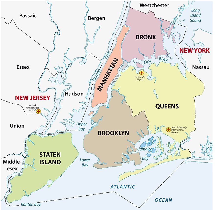
New York City is made up of five boroughs: Manhattan, Queens, Brooklyn, the Bronx, and Staten Island. Each of the boroughs is coextensive with a county (i.e., the boroughs share the exact boundaries as the counties)
- Bronx Borough = Bronx County
- Brooklyn Borough = Kings County
- Manhattan Borough = New York County
- Queens Borough = Queens County
- Staten Island Borough = Richmond County
The five boroughs are joined by shared water boundaries (East River and Hudson River) and connected by roads, subways, bridges, and so on.
The population of Counties in New York
The most populated counties in New York State are:
- Kings County, with 2,505,390 people
- Queens County, with 2,191,620 people
- New York County, with 1,627,660 people
- Suffolk County, with 1,463,910 people
- Bronx County with, 1,376,570 people
The least populated counties in New York State are:
- Schoharie County, with 30,558 people
- Lewis County, with 25,726 people
- Yates County, with 24,799 people
- Schuyler County, with 17,576 people
- Hamilton County, with 4,368 people
Population Density in New York State Counties
The population density in New York State by county map shows that the counties with the highest population densities are New York County, Kings County, Queens County, Bronx County, and Richmond County.
- New York County has a population density of 48,180 people per square mile.
- Kings County has a population density of 26,525 people per square mile.
- Bronx County has a population density of 24,593 people per square mile.
- Queens County has a population density of 12,797 people per square mile.
- Richmond County has a population density of 4,609 people per square mile.
Fun Facts about New York State Counties
The counties of New York are a unique aspect of the state. Each county has its history and features. Here are some interesting facts:

- Hamilton County is the least populated county in New York under 15,000 people
- There 5 counties that don’t have individual county seats. They are New York County, Kings County, Bronx County, Richmond County, and Queens County. Did you notice what is common to all of them? They’re all New York City boroughs! New York City is considered the county seat for the five counties/boroughs.
- Albany County houses the New York State Capitol, which is the seat of the state government of New York.
- Washington County was named after George Washington, the first president of the United States
- Jefferson County was named after Thomas Jefferson, the third president of the U.S. and author of the Declaration of Independence.
- Eight counties in the United States use the name Orange. Orange County in New York State was the first. The county is named after William III of Orange.
Abolished New York Counties
So far, seven counties have been abolished due to renaming, relocation, portioning, and so on. They are:
Charlotte County, Cornwall County, Cumberland County, Dukes County, Gloucester County, Mexico County, and Tryon County. Mexico County was the last to be abolished in 1796.
New York Counties FAQs
Q: What County is New York City a part of?
A: New York City is not in any one county. Instead, it contains five counties. They are New York County, Kings County, Bronx County, Richmond County, and Queens County.
Q: Which is the largest county in New York?
A: The largest county in New York is St. Lawrence County, with 2,821 square miles.
Q: What is the smallest county in New York?
A: The smallest county in New York is New York County, with 34 square miles.
Q: How many counties are there in New York?
A: There are 62 counties in New York.
Q: Which is the newest county in New York?
A: Bronx County is the newest county in New York, which was created in 1914.
Q: What County is Manhattan in?
A: Manhattan is a borough in New York City that shares boundaries with New York County.
Q: What County is the Bronx in?
A: The Bronx is both a county and a borough. It was the last county to be incorporated and is home to the Yankee stadium.
Q: Which counties in New York have the most land area?
A: The five counties with the most land area in New York are:
- Saint Lawrence County (2,680.38 square miles)
- Essex County (1,794.23 square miles)
- Hamilton County (1,717.37 square miles)
- Franklin County (1,629.12 square miles)
- Delaware County (1,442.44 square miles)
Q: What County Is Staten Island in?
A: Staten Island is a part of Richmond County.
Q: What are the counties in New York with the most people?
A: The most populated county in New York State is Kings County.
Q: Which counties in New York are the least populated?
A: Hamilton County is the least populated county in New York.
Q: What County is Brooklyn, NY within?
A: Brooklyn is in Kings County. It’s more accurate to say that Brooklyn is the same as Kings County as they share the exact boundaries.
Q: What County is Queens, NY in?
A: Like the Bronx, Queens is both a county and a borough and was established in 1683.